[ad_1]
What We Know about Taiwan’s Magnitude 7.4 Earthquake
An earthquake scientist discusses what we know about Taiwan’s magnitude 7. quake so far and what may happen next

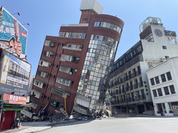
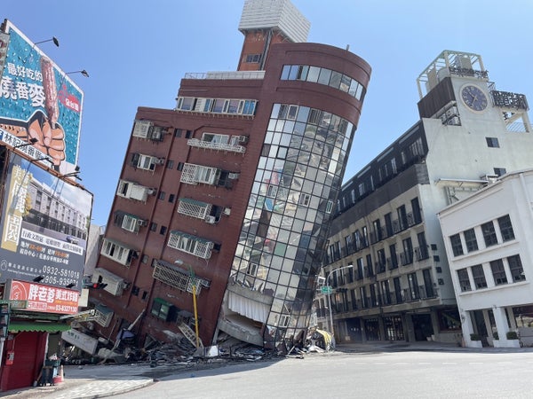
The Uranus Building at Xuanyuan Road is tilted severely as at least four people were killed and hundreds of others injured after a magnitude 7.4 earthquake struck off Taiwan’s eastern coast on the Richter scale, in Hualien, Taiwan on April 3, 2024.
Hualien County Fire Department/Anadolu via Getty Images
The following essay is reprinted with permission from ![]() The Conversation, an online publication covering the latest research.
The Conversation, an online publication covering the latest research.
Earlier today, a major earthquake of magnitude 7.4 struck the central east coast of Taiwan, roughly 20 kilometres south of the city of Hualien.
Locals near the epicentre described severe to violent ground shaking during the quake – strong enough to make standing and driving a vehicle difficult. It was reportedly felt across the country, as well as in neighbouring China.
On supporting science journalism
If you’re enjoying this article, consider supporting our award-winning journalism by subscribing. By purchasing a subscription you are helping to ensure the future of impactful stories about the discoveries and ideas shaping our world today.
So, what do we know so far about the quake and what the impacts may be?
Death and damage
News outlets have reported at least four people have died and dozens were injured as a result of the quake.
While much of Taiwan’s population lives on the west coast of the country, Hualien City is one of the largest population centres on the east coast. Its population is roughly 100,000.
Building damage has been reported in the region near the epicentre of the earthquake, including in Hualien City.
Landslides also occurred along the mountainous central east coast.
A tsunami warning was issued for Taiwan and nearby countries including Japan and the Philippines. At the time of writing, a 30 cm tsunami was reported along the south coast of Japan. This would have shown up as a noticeable swell on the shore but is unlikely to cause significant damage.
The biggest surge in a tsunami is not always the first surge so it is possible a larger tsunami wave may eventuate, but as time passes this becomes increasingly unlikely.
Was there any warning?
Although earthquakes cannot be predicted, Taiwan has an early warning system.
This system detects ground shaking as it happens in the epicentral region, and immediately sends an alert which travels faster than the seismic energy and associated ground shaking.
It likely provided crucial seconds of warning for those living away from the epicentre to take cover.
What kind of quake was it?
Initial estimates suggest the earthquake rupture began between 10 and 40 kilometres beneath the earth’s surface.
A shallower earthquake will generally produce stronger ground shaking than a deeper earthquake, and is therefore more likely to result in damage to nearby buildings.
The latest analysis of data from this earthquake suggests the earthquake was at the shallow end of this range, and likely produced a rupture which broke the surface. Satellite data of the Earth’s surface will tell us more about ground deformation within the coming days.
The earthquake rupture occurred on a reverse fault. This is where the quake lifts up one side of the Earth’s crust relative to the other. This can produce a vertical displacement of the ocean floor, which can generate a tsunami.
Approximately three hours after the initial quake, there have already been 13 aftershocks greater than magnitude 5.0 – all large enough to produce their own ground shaking across much of the country.
Strong aftershocks may cause the collapse of buildings that were only damaged in the main shock.
A history of quakes in the area
The Hualien region has experienced earthquakes before.
In February 2018, this region produced an earthquake of magnitude 6.4, which sadly resulted in 17 deaths.
That earthquake was the main event of a sequence of seismic events in early 2018, including a foreshock of magnitude 6.1. A foreshock is an earthquake of smaller magnitude which precedes a larger earthquake in the same region within days or weeks. We don’t know a quake is a foreshock until the mainshock occurs.
According to my analysis of available earthquake data, the Hualien region experiences earthquakes bigger than magnitude 7 about once every 30 years.
The largest recent recorded earthquake in onshore Taiwan was the magnitude 7.6 Chi-Chi quake (sometimes spelled in English as the Jiji quake) that struck in 1999.
More than 2,400 people lost their lives as a result of this earthquake.
Today’s magnitude 7.4 earthquake will likely continue to produce aftershocks for days and weeks to come.
We can’t rule out the possibility today’s earthquake was not even the biggest event in this sequence, although as time passes the likelihood of a larger associated event decreases.
Where can I get more information?
Be cautious about what you see or read on social media; in the initial aftermath of a natural disaster people often share footage that actually depicts other disasters.
For updates, I recommend following Taiwan’s Central Weather Administration, which is reporting on aftershocks and tsunami warnings as more information comes to hand.
This article was originally published on The Conversation. Read the original article.
[ad_2]