[ad_1]
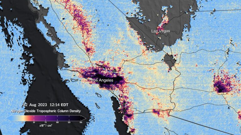
The first images from NASA’s new spaceborne air pollution sensor reveal how levels of toxic pollutants change within a day across the United States.
The images taken by the Tropospheric Emissions: Monitoring of Pollution instrument, or TEMPO, show the daily evolution of nitrogen oxide concentrations in major North American cities including Los Angeles, Las Vegas, New York, Washington and New Orleans. Nitrogen oxide is a toxic pollutant that comes from fossil fuel combustion. In high concentrations, the gas can harm the human respiratory tract and contribute to the development of asthma. Detailed understanding of how its concentrations vary over the course of a day and a year will help authorities to better inform the public so that people can better protect their health. Nitrogen oxide is, however, only one of many toxic pollutants that TEMPO can detect.
“TEMPO is beginning to measure hourly daytime air pollution over greater North America,” Kelly Chance, a senior physicist at the Smithsonian Astrophysical Observatory (which cooperates on the mission with NASA) and TEMPO principal investigator, said in a statement. “It measures ozone, nitrogen dioxide, formaldehyde, aerosols, water vapor and several trace gases,” she added.
Related: Canadian wildfire smoke dims the vision of Earth-observing satellites (photos)
TEMPO, which is mounted on a commercial telecommunication satellite Intelsat 40e, made the measurements that form the basis of the released maps during its testing period between July 31 to Aug. 2.
The Intelsat 40e satellite sits in geostationary orbit, a ring at the altitude of 22,000 miles (36,000 kilometers). At this altitude, satellites orbit Earth at a speed that matches the planet’s rotation, which makes them appear suspended above a fixed spot above the equator. Thanks to this clever trick of orbital mechanics, satellites in geostationary orbit have a constant view of certain parts of the Earth’s globe.
This position enables TEMPO to make hourly measurements of air pollution levels across America from the Atlantic to the Pacific Coast, from as far south as Mexico City all the way up to central Canada.
TEMPO measures reflected sunlight scattered off Earth’s surface, clouds and atmosphere. As different gases absorb different wavelengths of light, the resulting spectra (wavelength fingerprints of the measured light), correspond with the composition of the air and the concentrations of various chemical compounds present in it.
The mission launched in April on a SpaceX Falcon 9 rocket, but it took several months for the satellite to reach its correct position so that the instrument testing could commence. Now in place and tested, TEMPO will become the first satellite to provide scientists with real time air-pollution measurements over North America.
“Neighborhoods and communities across the country will benefit from TEMPO’s game-changing data for decades to come,” NASA Administrator Bill Nelson said in the statement. “This summer, millions of Americans felt firsthand the effect of smoke from forest fires on our health. NASA and the Biden-Harris Administration are committed to making it easier for everyday Americans and decisionmakers to access and use TEMPO data to monitor and improve the quality of the air we breathe, benefitting life here on Earth.”
[ad_2]
