
[ad_1]
CNN
—
As severe storms prompted overnight tornado reports in parts of the central US, a barrage of snow, rain and harsh winds are forecast across large swaths of the US as more storms sweep from Washington state to southern California and across the Great Lakes region on Monday, pummeling areas where hundreds of thousands are still without power after a similar string of severe weather last week.
At least two tornadoes were confirmed in Oklahoma, where about 60,000 energy customers were without power early Monday, according to outage tracker PowerOutage.us.
More than 100 other storm reports – including wind and hail – were recorded in parts of Oklahoma, Kansas and Texas as hurricane-force winds and severe thunderstorms tore through the states. A gust of 114 mph was recorded In Memphis, Texas – equivalent to a category 3 hurricane.
In anticipation of severe winds and potential hail Sunday night and into Monday, an Air Force unit at McConnell Air Force Base in Wichita, Kansas, relocated most of its aircraft to protect them from damage and ensure they can still be deployed if needed, the base announced.
In the West – where last week’s storms prompted rare blizzard warnings and road flooding in California – rain and high-elevation snow will push from the Pacific Northwest down into California and into the Rockies through Monday.
Yosemite National Park was closed Saturday due to severe weather and will not reopen until at least Wednesday as a multi-day blizzard warning remains in effect across Yosemite Valley, the park announced. Yosemite Valley could see as much as 55 to 84 inches of snow by Wednesday, the park said.

Approximately 284,000 homes and businesses were without power across the US as of early Monday, about half of which were in Michigan, where the Great Lakes region is bracing for another round of ice and snow on Monday after being struck by last week’s multi-day storm.
The winter storm is then expected to push into the Northeast by Monday afternoon, where interior parts of the region could see widespread snowfall totals of 6 to 12 inches.
Meanwhile, the South is anticipating another week of unusually warm winter temperatures after steaming under record-breaking highs last week.
Dozens of daily high temperature records could be broken again in the coming days as areas of southern Texas and the Florida peninsula could see temperatures into the 90s.
More than 20 million people were under threat of severe storms stretching from western Texas to Illinois on Sunday.
The Storm Prediction Center forecast a severe storm event — known as a derecho — would sweep through the region Sunday afternoon and into the evening, with a particular focus on parts of Oklahoma.
A derecho is a widespread, long-lived windstorm that typically causes damage in one direction across a relatively straight path, according to the National Weather Service. To be classified as a derecho, the stretch of wind damage should extend more than 240 miles and include wind gusts of at least 58 mph along most of its length, it says.
In total, more than 115 storm reports were made Sunday across the Southern Plains, mainly of wind across Kansas, Texas and Oklahoma. This also includes 14 hail reports in those states, with several hailstones reportedly 1.75 inches in diameter.
Nine tornadoes were reported in Oklahoma and Kansas, including one in the Oklahoma city of Norman, where police warned of multiple road closures, downed power lines and debris.
Students on the campus of the University of Oklahoma in Norman were told to immediately take shelter Sunday evening as the area was under a tornado warning, which was lifted later that night.
Roughly a dozen families displaced by a tornado in Liberal, Kansas, are being accommodated and about 10 trailers were also damaged, City Manager Rusty Varnado said. At least one person was injured by broken glass, he said, noting the injuries are minor.
Freezing rain, snow and ice across the Great Lakes region and parts of the Midwest last week resulted in perilous travel conditions, road closures and significant power outages that disrupted daily life for many.
This week, the Great Lakes are poised to be hit all over again, including Michigan where about 146,000 homes and businesses still do not have power after the prior storms damaged trees and utility lines.
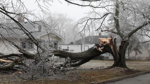
Utility company DTE, one of Michigan’s largest electricity providers, said 630,000 of its customers have been impacted by the storms so far. By Sunday night, power was restored to about 600,000 of their customers, the utility said.
Another round of mixed precipitation is expected to move into the region Monday, with those under winter weather alerts possibly seeing between 2 to 8 inches of snowfall.
As the storm moves eastward, winter storm watches are also in effect for parts of interior New York and New England through Wednesday afternoon. In total, these isolated areas can see up to 10 inches of snowfall.
Boston, which is under a winter weather advisory from Monday evening until Tuesday evening, is expected to get 2 to 5 inches of snowfall.
[ad_2]